

Description
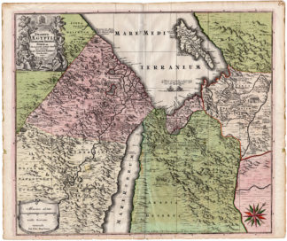
Subject: Antique print, titled: ”Deserta Aegypti, Thebaidis, Arabia, Syrae etc.” – (Desert regions of Egypt, Sudan, Arabia, Syria, etc.) Original antique map of A map showing the countries of the Eastern Mediterraniean: Turkey, Syria, Israel, Palestine and Egypt, with the places inhabited by the Anachorets.
Condition: Very good, given age. Original fold as issued. Paper separation at lower middle fold, backed. Paper edges irregular with several small tears, not effecting image. Contemporary colouring. General age-related toning and/or occasional minor defects from handling. Please study scan carefully.
Medium: Original handcoloured engraving on hand laid (verge type with chainlines) paper. Watermark: Coat of arms.
Size (in cm): The overall size is ca. 63 x 52.5 cm. The image size is ca. 57.5 x 49.5 cm.
Size (in inch): The overall size is ca. 24.8 x 20.7 inch. The image size is ca. 22.6 x 19.5 inch.
Part Number: 66394
Location: PCO-B1-13
Description: From a Seutter atlas, to be determined. The map is a reduced version of the Etienne Michalet’s map of 1697.
Artists and Engravers: Made by ‘Gottfried Rogg’ after ‘Mattheaus Seutter’. Gottfried Rogg (German; 1669-1742). Matthaeus/Mattheus/Mattias Seutter (1678-1756) was an engraver, globe-maker and map publisher from Augsburg. He was a pupil of J.B. Homann in Nuremberg. Seutter was awarded the title of Imperial Geographer by Karl VI in 1731. He made several atlases as a folio-atlas in two versions in 1720. Seutter’s most well-known works are the 1725 “Atlas Geographicus oder Accurate Vorstellung der ganzen Welt” with 46 maps, the 1734 “Grosser Atlas” with 131 maps, and the 1744 pocket atlas “Atlas minor” with 64 maps. Matthäus Seutter died in 1757. Seutter’s son Albrecht Karl, his son-in-law Conrad Tobias Lotter, and his business partner Johann Michael Probst ran the printing business for five more years.


Reviews
There are no reviews yet.