

Description
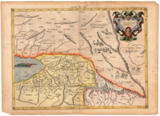
Subject: Antique print, titled: ”Asiae Tab. VII. (On map: Scythia intra Imaum …).” – Original antique map of Ancient Scythia. A beautiful Ptolemaic map Central Asia east of the Caspian Sea and what is now Turkestan, the Steppes, Afghanistan and beyond. The Himalayas and Northern India run across the bottom of the map. Embellished with a sea monster, and nomadic figures with lifestock inhabiting the steppes. With a decorative, scrollwork cartouche.
Condition: Very good, given age. Original fold as issued. Some paper loss at corners margin, not effecting image. Paper edges with some chipping. General age-related toning and/or occasional minor defects from handling. Please study scan carefully.
Medium: Hand coloured engraving on hand laid (verge type with chainlines) paper. Watermark: coat of arms
Size (in cm): The overall size is ca. 53 x 38.5 cm. The image size is ca. 46 x 34.5 cm.
Size (in inch): The overall size is ca. 20.9 x 15.2 inch. The image size is ca. 18.1 x 13.6 inch.
Part Number: 66402
Location: PCO-B1-12
Description: From the an early ed. of Mercator’s Ptolemy Atlas: ‘Claudii Ptolemaei Tabulae Geographicae Orbis Terrarum Veteribus Cogniti.’ This Atlas was first published in 1578 and re-published in 1584, 1605, 1618/1619, 1695, 1698, 1704 and 1730. For the 1698 ed. the plates were reworked wit new cartouches and a new title engraving. Of all the editions of Ptolemy the Mercator editions are considered the finest in execution. It was Mercator’s intention to produce an Atlas of the classical world, not a current atlas, made as a companion to his modern atlas. We have not been able to determine the exact pre 1798 ed. of this map. Any input appreciated. State: 1st State, before the rework in 1698.
Artists and Engravers: Made by ‘Gerard Mercator’ after ‘Ptolemy’. Gerard Mercator (Kremer) was born in Rupelmonde in Flanders and studied in Louvain. He made his first map in 1537 and became a cartographer and globe maker. In 1552 he moved to Duisburg, Germany where he published his famous 18-sheet world map in 1569 with his own new projection, today called Mercator projection. Later he decided to publish a new edition of Ptolemy’s Geographia. Followed by his major work, a 3 volume collection of maps to which the word “Atlas” was applied the first time. The first volume was published 1585, followed by the second in 1589 and the third one after his death in 1595 by his son Rumold. A second edition of all three parts was published 1602. In 1604 Jodocus Hondius acquired the plates and published several editions together with his sons Jodocus II and Henricus until 1633. More editions followed until 1666 by Janssonius who was in partnership with Henricus. Some of the plated where also used in W.J. Blaeu in 1630.

Reviews
There are no reviews yet.