

Description
Engraving on hand laid paper. on paper.
Size in cm: The overall size is ca. 93.6 x 64.5 cm. The image size is ca. 87.7 x 57 cm. Size in inch: The overall size is ca. 36.9 x 25.4 inch. The image size is ca. 34.5 x 22.4 inch.
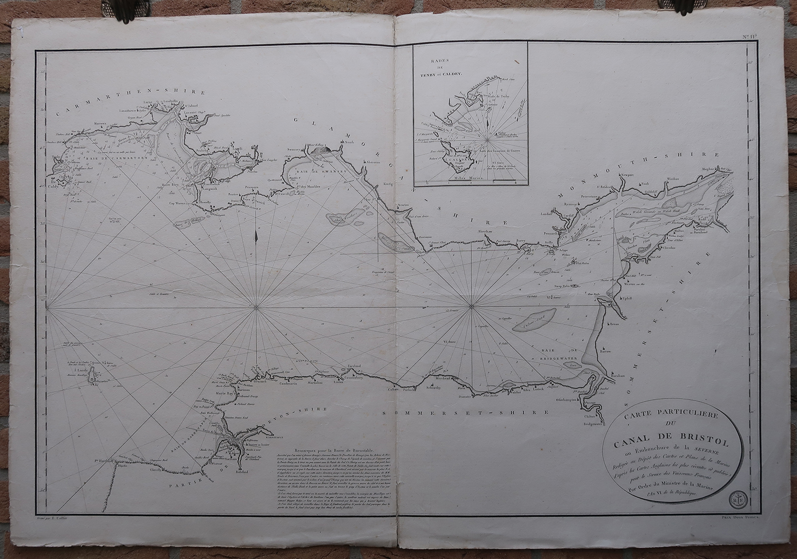
Antique map, titled: ”Carte Particuliere du Canal de Bristol ou Embouchure de la Severne […].” – A coast chart of the English West coast, specifically the Bristol Channel between Cornwall and Wales. This map shows Lundy island, and cities Barnstaple, Swansea, Cardiff and Portishead. Depth soundings in the channel, and several coastal towns indicated, as well as some sand banks. An inset map in the top edge shows the area near Tenby and the island Caldey (Ynys Byr). Published by the Depot des Cartes et Plans de la Marine, in year 6 (1797-1798) of the Republican calendar. Probably from a ‘Pilote des Iles Britaniques …’, made for the planned invasion of Napoleon into Britiain. Many of the maps were based on British maps by John Knight ao.Artists and Engravers: Made by ‘E. Collins’ after ‘Depot de la Marine’. Depot des Cartes et Plans de la Marine (1720 – present), often called the Depot de Marine, was a French hydrographic mapping organization founded in 1720. Much like the U.S. Coast Survey, the British Admiralty, and the Spanish Deposito Hydrografico, the Depot was initiated as a storehouse and distribution center of existing nautical and marine charts. Eventually the Depot initiated its on mapping activities in an attempt to improve and expand upon existing material. Some of the well known hydrograhers / cartographers in the development of Depot were Jacques Nicholas Bellin and Riobert Bonne.
Condition: Good, given age. Original middle fold, as issued. A dampstain and a small tear in the left and right margins. Some small tears, creases and nicks in the margins (not affecting image). Paper separation in the top middle fold (with old restoration), and in the lower middle fold. General age-related toning and/or occasional minor defects from handling. Please study scan carefully.
Keywords: ANTIQUE MAP-SEA CHART-BRISTOL CHANNEL-WALES-CORNWALL-DEPOT DE LA MARINE
(PCO) GK-179
![CCCLXXXIV. Victoria post sitim restinctam. [Johann SCHEUCHZER after HEUMANN, 1731]](https://pictura-prints.com/wp-content/uploads/2018/10/pcom-0759-e1540471972803-324x523.jpg)

Reviews
There are no reviews yet.