


Description
Engraving on hand laid (verge) paper. on paper.
Size in cm: The overall size is ca. 99 x 65.5 cm. The image size is ca. 93.5 x 59.5 cm. Size in inch: The overall size is ca. 39 x 25.8 inch. The image size is ca. 36.8 x 23.4 inch.
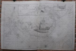
Antique map, titled: ‘The River of Thames from London to the Buoy of the Noure.’ – A very large map of the English coast, from Dover and Ramsgate/Margate north to the mouth of River Humber, around Grimsby. Depth soundings are indicated, as well as sand banks and shallows. An inset map of the course of the Thames, from its mouth to London. A decorative cartouche in the center of the sheet with several sailing ships. Originally printed in two separate sheets, here joined together. Published by Richard Mount, London. The chart was publshed in ‘Great Britain’s Coasting Pilot’, an atlas of 48 charts of British waters surveyed by Captain Greenvile Collins between 1681-88. Collins, who was made Hydrographer to King Charles II in 1679, was sponsored by Trinity House, the corporation in charge of Britain’s lighthouses, buoys and other navigational aids, to whom this chart is dedicated. Artists and Engravers: Made by ‘J. Harris’ after ‘Greenville Collins’. Capt. Greenville Collins (1643-1694). Collins, who was made Hydrographer to King Charles II in 1679, was sponsored by Trinity House, the corporation in charge of Britain’s lighthouses, buoys and other navigational aids.
Condition: Very good, given age. Original folds (as issued). Minimal paper separation in the folds and fold intersections (backed). Some scattered tiny stains. The two sheets joined imperfectly. General age-related toning and/or occasional minor defects from handling. Please study scan carefully.
Keywords: ANTIQUE MAP-COASTAL MAP-ENGLAND-LONDON-THAMES-SEA CHART-COLLINS-HARRIS
(PCO) GK-131


Reviews
There are no reviews yet.