


Description
Medium: Colour lithograph on wove (vellin) paper.
Sheet size: 75 x 50 cm (29.53 x 19.69 inch). Image size: 66 x 43 cm. (25.98 x 16.93 inch).
Condition: very good, given age. Clean print with minor signs of age, slight creasing along folds. General age-related toning and/or occasional minor defects from handling. Please study scan carefully.
ROTTERDAM, NETHERLANDS, 16TH-CENTURY MAP, JACOB VAN DEVENTER, HISTORICAL CARTOGRAPHY, URBAN PLANNING, FORTIFIED CITIES, ANTIQUE MAP | MAPS-NETHERLANDS-OVERSIZE
BACKGROUND INFORMATION
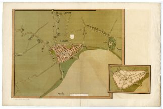
Original map created by Jacob van Deventer (1558-1563), copied by M.N. Rotteveel (1891), held in the Biblioteca Nacional, Madrid.
Reference: A. Gordijn & P. Ratsma, Catalogus kaartenverzameling (1984), nr. 12; A. van der Schoor, Stad in aanwas (1999); Kaarten en kaartmakers van Rotterdam (1984 exhibition catalog).
Biography artist: Jacob Roelofs van Deventer (c. 1500-1575) was a Dutch cartographer, commissioned by Philip II of Spain to create detailed city maps of the Low Countries. His maps are among the earliest systematic urban surveys.


Reviews
There are no reviews yet.