


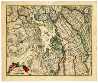
Description
Medium: Etching, engraving, hand-colored on hand-laid (verge) paper.
Sheet size: 49.1 x 58.3 cm (19.33 x 22.95 inch). Image size: 44.5 x 54.1 cm. (17.52 x 21.3 inch).
Condition: very good, given age. Vertical center folding as issued, light foxing, creasing and soiling. Soem paper separation at top and bottom middle fold, backed. General age-related toning and/or occasional minor defects from handling. Please study scan carefully.
SOUTH HOLLAND, BIESBOSCH, ANTIQUE MAP, FREDERIK DE WIT, DUTCH CARTOGRAPHY, 17TH-CENTURY MAP, NETHERLANDS, HAND-COLORED ENGRAVING | MAPS-NETHERLANDS-OVERSIZE
BACKGROUND INFORMATION
Published in various editions of Atlases by Frederik de Wit between 1688 and 1710.
Reference: Koeman, WIT25.
Biography engraver: Frederik de Wit (c.1629-1706) was a Dutch cartographer and engraver, known for his beautifully decorated maps and atlases. His publishing house became one of the most influential in the late 17th century.

Reviews
There are no reviews yet.