


Description
This rare print shows the uncommon map which focuses on the fictitious Ptolemaic twin lakes of Zaire and Zaflan. The large lakes, purported to be the source of the Nile were thought to be located at the foot of the mythical Lunae Montes, or Mountains of the Moon, often identified as the Ruwenzori Mountains in Uganda. The map is filled with fictitious place names and topography, all meticulously detailed.
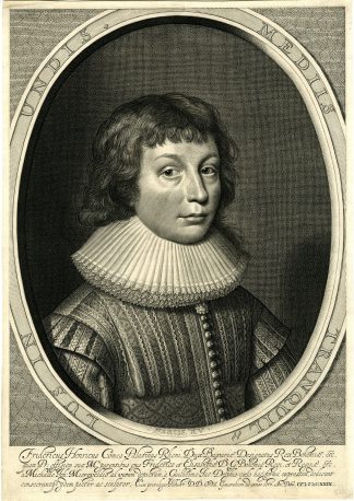
Made by Antoine de Winter after Nicholas Sanson d?Abbeville.
Medium: Engraving / etching on hand laid (verge) paper.
Sheet size: 22.5 x 31.5 cm (8.86 x 12.4 inch). Image size: 21 x 29.5 cm. (8.27 x 11.61 inch).
Condition: good, given age. Fold as published. Two small tears in margin restored. Remains of tape. Two wormholes. Brown spot in right margin. General age-related toning and/or occasional minor defects from handling. Please study scan carefully.
NUBIE-PTOLEMAIC TWIN LAKES-ZAIRE-ZAFLAN-LUNAE MONTES-RUWENZORI MOUNTAINS-UGANDA-AFRICA- | RBOS-A9-39
BACKGROUND INFORMATION
This attractive print was published in ‘Geographische Historiche Beschryvingh der vier bekend Werelds-Deelen…’, Paris 1693.
Biography engraver: Anthonie de Winter (1653-1707) was a Dutch engraver, etcher, publisher and art dealer. Son of Hendrik de Winter, a seal-engraver and silversmith.
Biography artist: Nicholas Sanson d’Abbeville (1600 ? 1667) and his descendents were important French cartographer’s active through the 17th century. Sanson started his career as a historian where, it is said, he turned to cartography as a way to illustrate his historical studies. In the course of his research some of his fine maps came to the attention of King Louis XIII who, admiring the quality of his work, appointed Sanson ‘Geographe Ordinaire du Roi’. Sanson’s duties in this coved position included advising the King on matters of Geography and compiling the royal cartographic archive. Sanson’s corpus of some three hundred maps initiated the golden age of French Cartography.


Reviews
There are no reviews yet.