


Description
Medium: Etching, engraving on hand-laid (verge) paper.
Sheet size: 64 x 54.5 cm (25.2 x 21.46 inch). Image size: 53 x 48 cm. (20.87 x 18.9 inch).
Condition: very good, given age. Light foxing, creasing and soiling, original fold lines, small signs of handling. General age-related toning and/or occasional minor defects from handling. Please study scan carefully.
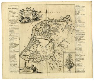
FRIESLAND HISTORICAL MAP, BATAVIANS, CASPAR LUYKEN, BERNARDUS SCHOTANUS ? STERRINGA, FRAN?OIS HALMA, DUTCH CARTOGRAPHY, ROMAN NETHERLANDS, ANTIQUE FRIESLAND MAP | PCO-B1-18
BACKGROUND INFORMATION
Originally published in Descriptio agri Batavi & Frisii by Menso Alting (1697-1700), later reprinted in Halma’s Tooneel der Vereenigde Nederlanden (1725) and Uitbeelding der Heerlijkheit Friesland (1718). Published by Fran?ois Halma in Leeuwarden.
Reference: FMH 26-A, Van Eeghen 2196-3(3).
Biography engraver: Jan Luyken (1649-1712) was a Dutch illustrator, poet, and engraver known for his book illustrations, including biblical scenes, historical maps, and emblematic prints.
Biography artist: Menso Alting (1637-1719) was a Dutch historian and geographer, known for his descriptions of the Batavian and Frisian lands in historical and cartographic works.

Reviews
There are no reviews yet.