
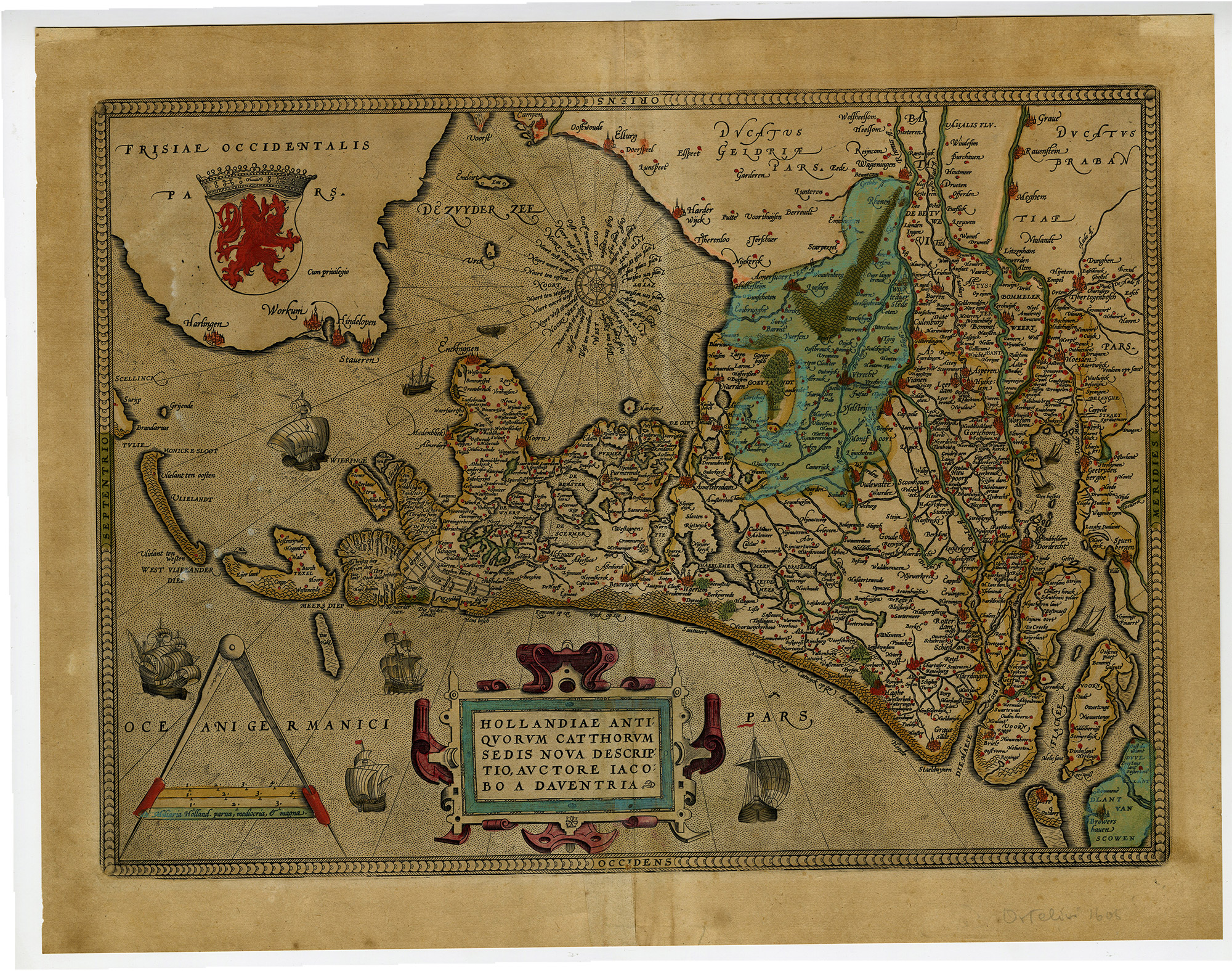
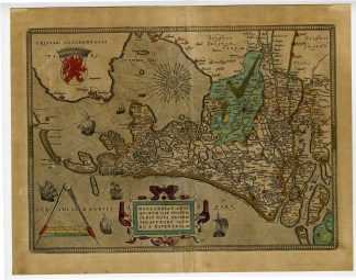
Description
Medium: Copperplate engraving, hand-colored on hand laid (verge) paper.
Sheet size: 54 x 42 cm (21.26 x 16.54 inch). Image size: 47 x 33.5 cm. (18.5 x 13.19 inch).
Condition: good, given age. Some toning and minor foxing, well-preserved hand coloring, strong impression. Original vertical fold as issued. . General age-related toning and/or occasional minor defects from handling. Please study scan carefully.
HOLLAND, 16TH CENTURY MAP, JACOB VAN DEVENTER, DUTCH CARTOGRAPHY, HISTORICAL MAPS, RENAISSANCE MAPS, COUNTY OF HOLLAND, ANTIQUE MAPS | MAPS-LARGE
BACKGROUND INFORMATION
Published in 1570, based on systematic surveys by Jacob van Deventer. This plan originates from the famous city Atlas: ‘Civitates Orbis Terrarum’, published in 1575-1612. Artists and Engravers: Georg Braun (1542-1622) and Franz Hogenberg (1533-1588).
Reference: Referenced in Leven en werk van cartograaf Jacob van Deventer and De stadsplattegronden van Jacob van Deventer.
Biography engraver: Georg Braun (1542-1622), a German publisher and Frans Hogenberg issued the famous six volume town book ‘Civitates Orbis Terrarum’ between 1572 and 1618. The volumes originally published in Latin, follow by German and French translations. The plates passed to Jan Janssonius who reissued the town books in 1657 while removing the costume figures on the plates. Franz Hogenberg (1533-1588) was the son of a Munich engraver who settled in Malines. He engraved most of the plates for Ortelius’ Theatrum and the majority of those in the Civitates, and may have been responsible for originating the project. Worked and died in Cologne/Germany. He was a prolific copper engraver and etching artist of maps and town views. In cooperation with Georg Braun he created the first four volumes of the Civitates Orbis Terrarum in 1572. The fifth and sixth volume was created by Simon van den Neuwel (Novellanus). This map was made by the Dutch cartographer Jan van Liefrinck, who was active in Leiden in 1567 and died there in 1599. He received payment on 22 August 1580 from the Leiden Magistracy for his map and view of the city, which was destined for Plantijn’s edition of Guicciardini’s Descrittione, 1581.
Biography artist: Jacob Roelofs van Deventer (c. 1500/1505-1575) was a Dutch cartographer known for systematically mapping the towns and cities of the Habsburg Netherlands. He was among the first to use triangulation techniques in mapmaking. His works remained unpublished for military reasons and were rediscovered in the 19th century.


Reviews
There are no reviews yet.