


Description
Medium: Copper engraving on hand laid (verge) paper.
Sheet size: 45.4 x 34.3 cm (17.87 x 13.5 inch). Image size: 35.5 x 27 cm. (13.98 x 10.63 inch).
Condition: good, given age. Well-preserved, sharp impression, minimal toning, blank verso. Light foxing, creasing and soiling. General age-related toning and/or occasional minor defects from handling. Please study scan carefully.
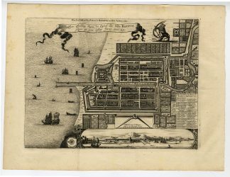
BATAVIA, JAKARTA, DUTCH EAST INDIES, VOC, PIETER VAN DER AA, 17TH-CENTURY CITY PLAN, COLONIAL HISTORY, ANTIQUE MAP, LA GAL?RIE AGR?ABLE DU MONDE | EXPO-MAPS-LARGE
BACKGROUND INFORMATION
La Galerie Agreable du Monde, Pieter van der Aa, 1728. Originally published in Gedenkwaardige gesantschappen der Oost-Indische Maatschappy (1669).
State: Later edition, based on the 1669 map.
Reference: Van der Krogt 4 – #1951; Van der Krogt A – 54:33.
Biography engraver: Pieter van der Aa (1659-1733) was a Dutch publisher and bookseller based in Leiden. He specialized in geography and travel books, producing numerous atlases and city plans. He often republished earlier works, combining original material with reprints from other cartographers.

Reviews
There are no reviews yet.