

Description
Lithograph on a vellin type of paper. on paper.
Size in cm: The overall size is ca. 7.3 x 9.3 cm. The image size is ca. 6 x 8.2 cm. Size in inch: The overall size is ca. 2.9 x 3.7 inch. The image size is ca. 2.4 x 3.2 inch.
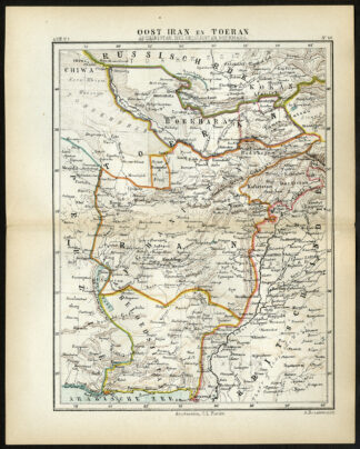
Plate 46 : ‘Oost Iran en Toeran. Afghanistan, Beloedsjistan, Boekhara.’ (East Iran and Turan / Afghanistan, Balochistan, Bukhara). This lithographed map originates from: ‘Wereld-atlas voor Kantoor en Huiskamer’ (transl: World Atlas for the office and living room), by J. Kuyper, published in 1880 – 1882 in Amsterdam, The Netherlands by G. L. Funke.Artists and Engravers: Jacob Kuyper (1821 – 1908), Dutch cartographer.
Condition: Original middle fold as issued. General age-related toning and occasional light stains from handling. Please study image carefully.
Keywords: ANTIQUE MAP-EAST IRAN-PERSIA-PAKISTAN-AFGHANISTAN-BUKHARA-JACOB KUYPER
(PCO) C153-13

![RUSSIA-MUSCOVY-MICHAEL I-ROMANOV-CZAR-PORTRAIT [After OLEARIUS, 1719]](https://pictura-prints.com/wp-content/uploads/2019/03/pcom-0654-324x503.jpg)

Reviews
There are no reviews yet.