

Description
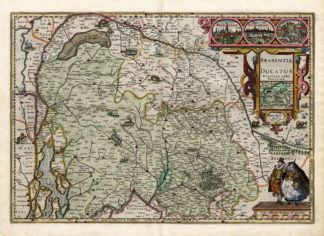
Subject: Title: ‘Abbeldinig des Fvrstendom Brabant mit die aengrender Lander. 1624’. Rare map of the Principality of Brabant with adjacent countries. West above. Title and year above the map. Bottom right compass rose. Verso unprinted.
Condition: Excellent given age.
Medium: Copperplate engraving on a verge type of hand laid paper.
Size (in cm): The overall size is ca. 40 x 28.5 cm. The image size is ca. 33 x 25 cm.
Size (in inch): The overall size is ca. 15.7 x 11.2 inch. The image size is ca. 13 x 9.8 inch.
Part Number: 38710
Location: PCO-P7-18 / Expo-192
Description: This map was published in 1627 by Schoenwetter – Kempffer in Frankfurt am Main, in the book ‘Ostereichischer Lorberkrantz Oder Kayserl. Victori …’ by Michael Caspar Lundorp.
Artists and Engravers: Michael Caspar Lundorp also known as Nicolaus Bellus (c.1580-1629), was a German historian and author. Engraver: Georg Keller (1568-1634), was a student of Jost Amman. He exibited a loose style of engraving.

![TITLE PAGE-TRAVEL-ELEPHANT-ASIA-PALM TREE [After DE MANDELSLO, 1719]](https://pictura-prints.com/wp-content/uploads/2019/03/pcom-0656-324x494.jpg)

Reviews
There are no reviews yet.