

Description
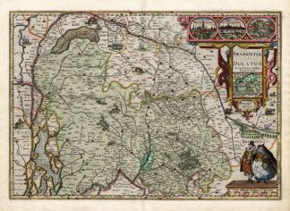
Subject: Title: ‘Brabantia Ducatus, Petrus Keerius caelavit’. Hertogdom Brabant. This map shows Dutch and Belgian Brabant. With cartouches, with pictures of Mechelen and Antwerp. With scale stick.
Condition: Excellent given age. Middle fold, as issued. Lower left corner chipped (not affecting image). General age-related toning and/or occasional light stains from handling. Please study scan carefully.
Medium: Copperplate etching / engraving on a verge type of hand laid paper. Later hand colouring.
Size (in cm): The overall size is ca. 54 x 41 cm. The image size is ca. 50 x 34.5 cm.
Size (in inch): The overall size is ca. 21.3 x 16.1 inch. The image size is ca. 19.7 x 13.6 inch.
Part Number: 38707
Location: PCO-P7-17 / Expo-172
Description: This original antique map originates from Van der Keere’s atlas ‘Germania Inferior’, published in 1617. A later ed. was published by Visscher. This Atlas is considered the most beautiful of the Low Countries (Netherlands, Belgium, Luxembourg) The maps by van der Keere stand out in their design and execution.
Artists and Engravers: Pieter van der Keere (also: Peter Kaerius, 1571-c.1646) was a Dutch engraver, publisher and globe maker. He was born in Ghent, but repatriated to London for religious reasons. In London he was trained by Jodocus Hondius, with whom he left for Amsterdam in 1593.
![TITLE PAGE-TRAVEL-ELEPHANT-ASIA-PALM TREE [After DE MANDELSLO, 1719]](https://pictura-prints.com/wp-content/uploads/2019/03/pcom-0656-324x494.jpg)

Reviews
There are no reviews yet.