

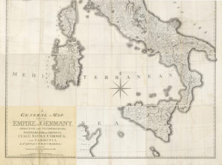
Description
Subject: 9 Antique maps. This very large multi-sheet map (9 sheets) shows Italy, Corsica and Sicily. (Sheet numbers 17-25 as indicated on the index map, Index included). The sheets are seperate sheets now, but could be pasted into one large map.
Condition: Very good, given age. Original middle fold. Some foxing in the middle folds. A few small tears in the margin edges (not nearly affecting image). A few of the sheets with ghosting from where the sheets were folded. Some general soiling and/or foxing in the margins. General age-related toning and/or occasional minor defects from handling. Please study scan carefully.
Medium: Engraving on wove paper.
Size (in cm): The overall size is ca. 246 x 195 cm. The image size is ca. 246 x 195 cm.
Size (in inch): The overall size is ca. 96,9 x 76,8 inch. The image size is ca. 96,9 x 76,8 inch.
Part Number: 58454
Location: PCO-P5-22 / Expo-181
Description: From: “A General Map of the Empire of Germany, Holland, the Netherlands, Switzerland, the Grisons, Italy, Sicily, Corsica, and Sardinia, by Captain Chauchards &c.”. Published in London: John Stockdale, 1800.
Artists and Engravers: Made by ‘John Stockdale ‘.


Reviews
There are no reviews yet.