
![Russiae, Moscoviae et Tartariae Descriptio (…) [Abraham ORTELIUS after , c. 1575]](https://pictura-prints.com/wp-content/uploads/2018/09/pco-2218.jpg "Pco 2218 416x329")
![Russiae, Moscoviae et Tartariae Descriptio (…) [Abraham ORTELIUS after , c. 1575] - Image 2](https://pictura-prints.com/wp-content/uploads/2018/09/pco-2220.jpg "Pco 2220 416x331")
Description
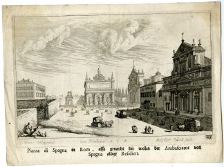
Russiae, Moscoviae et Tartariae Descriptio (…)
Copperplate engraving/etching with contemporary hand colouring. on hand laid (verge) paper.
Sheet size: 51,8 x 39,7 cm. Image size: 44,7 x 35 cm.
First published in 1570. From a German ed. of the ‘Theatrum …’ atlas by Ortelius. Ref: Van Den Broecke 162.
Made by Abraham Ortelius after Antonio Jenkensono. Abraham Ortelius was born 1528 in Antwerp. He studied mathematics, Greek and Latin and travelled a lot across Europe. He established a business in dealing with books and drawing maps. His first remarkable map was a 8 sheet world map in the year 1564, but only three copies have survived. In 1570 he issued the “Theatrum Orbis Terrarum”, the first modern “Atlas” with uniformly sized maps in a systematic collection. The term “Atlas” was not used until Mercator introduced it 20 years later. Most of the maps in Theatrum have been engraved by Frans Hogenberg. At the time of publication, the atlas was the most expensive book ever printed. Nevertheless it was a big success and around 7000 copies have been printed until 1612 in many editions and six different languages. Beside the Theatrum, Ortelius compiled a series of historical maps and published it in the “Parergon Theatri” which was bound with the Theatrum from 1579 onwards or published separately.
Condition: Very good, given age. Minor staining in the margins, not affecting image. Original middle fold as issued. General age-related toning and/or occasional minor defects from handling. Please study scan carefully.
Keywords: FINLAND-LAPLAND-RUSSIA-MOSCOW-OLD COLOURED
PCO-B4-01
![[Hubertus QUELLINUS] Four bas-reliefs representing the Four Elements (Amsterdam City Hall, 2 plates)](https://pictura-prints.com/wp-content/uploads/2018/07/pcom_0346-324x520.jpg)
![Musei Linckiani - Serpentes [Johann SCHEUCHZER after PINTZ, 1731]](https://pictura-prints.com/wp-content/uploads/2018/10/pcom-600-324x464.jpg)
![Ballistae [Johann SCHEUCHZER after LICHTENSTEGER, 1731]](https://pictura-prints.com/wp-content/uploads/2018/10/pcom-645-324x543.jpg)
![[Giuseppi VASI] Piazza di Colonna Trajana](https://pictura-prints.com/wp-content/uploads/2018/07/pcom-0489-324x215.jpg)
![EURASIAN COOT-COMMON-FULICA ATRA-SET 'Fulica' [SEPP and NOZEMAN, 1770]](https://pictura-prints.com/wp-content/uploads/2018/07/pcorc040-324x457.jpg)
![[Giuseppi VASI] Disegno dell'Anticaglia (?)](https://pictura-prints.com/wp-content/uploads/2018/07/pcom-0500-324x215.jpg)
![Sacra in Atrio intimo peragenda [Johann SCHEUCHZER after PINTZ, 1731]](https://pictura-prints.com/wp-content/uploads/2018/10/pcom-646-324x536.jpg)
![[SEPP and NOZEMAN] Fringilla flavirostris (Twite)](https://pictura-prints.com/wp-content/uploads/2018/07/pcorc232-324x457.jpg)
![Grus hirundove garrientes [Johann SCHEUCHZER after HEUMANN, 1731]](https://pictura-prints.com/wp-content/uploads/2018/10/pcom-621-324x536.jpg)
![[Hubertus QUELLINUS] Frieze with ornamental decorations](https://pictura-prints.com/wp-content/uploads/2018/07/pictura-02015-324x175.jpg)
![CURLEW SANDPIPER-CALIDRIS FERRUGINEA 'Tringa subarquata' [SEPP and NOZEMAN, 1770]](https://pictura-prints.com/wp-content/uploads/2018/07/pcorc287-324x230.jpg)
![CCCCLXXV. Jordanes pallio divisus. [Johann SCHEUCHZER after HEUMANN, 1731]](https://pictura-prints.com/wp-content/uploads/2018/10/pcom-0723-e1540471616760-324x502.jpg)
![HOODED CROW-CORVUS CORNIX 'Corvus Cornix' [SEPP and NOZEMAN, 1770]](https://pictura-prints.com/wp-content/uploads/2018/07/pcorc132-324x227.jpg)
![COMMON SCOTER-DUCK-MELANITTA NIGRA 'Anas Nigra' [SEPP and NOZEMAN, 1770]](https://pictura-prints.com/wp-content/uploads/2018/07/pcorc228-324x461.jpg)
![COMMON LOON-GREAT NOTHERN DIVER-GAVIA IMMER 'Colymbus glacialis' [SEPP and NOZEMAN, 1770]](https://pictura-prints.com/wp-content/uploads/2018/07/pcorc327-324x458.jpg)
![AFRICA-GUINEE-ENGLISH FORTRESS-COMMENDO 'Plan du fort Anglois de Commendo' [Jacobus SCHLEY after PREVOST, 1748]](https://pictura-prints.com/wp-content/uploads/2018/07/pco_1749-324x425.jpg)

![Title engraving [Johannes KIP after STRUYS, 1676]](https://pictura-prints.com/wp-content/uploads/2018/12/pco-1741-324x421.jpg)

![[Hubertus QUELLINUS] Peace, Justice and Prudence (3 plates)](https://pictura-prints.com/wp-content/uploads/2018/07/pcom_0281-324x472.jpg)
![Russiae, Moscoviae et Tartariae Descriptio (…) [Abraham ORTELIUS after , c. 1575]](https://pictura-prints.com/wp-content/uploads/2018/09/pco-2218-324x256.jpg)

Reviews
There are no reviews yet.