

Description
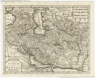
Subject: Antique print, titled: ‘Nieuwe Kaart van ‘t Ryk van Persie’ – (‘New map of the Persian Empire’). This antique map shows the Persian empire, at the time spanning from the Black Sea and Persian Gulf to the Caspian Sea. This region currently includes Iraq, Iran, Turkmenistan, Azerbaijan. Bodies of water include the Persian Gulf, Caspian Sea and Black Sea. Detailed map showing the locations of cities, mountain ranges, lakes and desert areas. With three different scales (German, English and French miles) and a compass rose.
Condition: Very good, given age. Original folds as issued. A few stains in the top margin. General age-related toning and/or occasional minor defects from handling. Please study scan carefully.
Medium: Engraving on hand laid paper.
Size (in cm): The overall size is ca. 39,8 x 32,7 cm. The image size is ca. 37 x 29,2 cm.
Size (in inch): The overall size is ca. 15,7 x 12,9 inch. The image size is ca. 14,6 x 11,5 inch.
Part Number: 69684
Location: PCO-B1-16
Description: From the 4th volume of “Hedendaagsche Historie of Tegenwoordige Staat van Alle Volkeren” (Tirion, 1732).
Artists and Engravers: Anonymous.


Reviews
There are no reviews yet.