

Description
Lithograph on thin wove paper. on paper.
Size in cm: The overall size is ca. 26.3 x 23.5 cm. The image size is ca. 23.8 x 21.8 cm. Size in inch: The overall size is ca. 10.4 x 9.3 inch. The image size is ca. 9.4 x 8.6 inch.
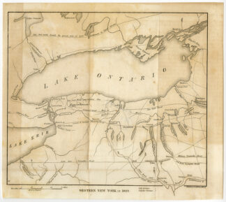
Antique print, titled: ‘Western New York in 1809.’ – A map of the region around Lake Ontario, in New York. The east half of Lake Erie is visible, and Oneida Lake on the right side of the map. This is a lithographically made map from ca. 1849. “Maps in the offices of Secr. Of State and Surveyor General”, Albany: Richard H. Pease, ca. 1850. Cartographers were David Vaughan, E.O. Olmsted and M.E. Seymour.Artists and Engravers: Made by ‘Richard H. Pease’ after ‘David Vaughan’. Printer / publisher: Richard H. Pease (1813-1869) was an engraver / lithographer and printer from Albany.
Condition: Good, given age. Original folds as issued. Faintly browned. General age-related toning and/or occasional minor defects from handling. Please study scan carefully.
Keywords: ANTIQUE PRINT-LAKE ONTARIO-ERIE-NEW YORK STATE-USA-VAUGHAN-PEASE
(PCO) C130-25

Reviews
There are no reviews yet.