

Description
Copper engraving on verge type hand laid paper with watermark. Original old hand colouring. on paper.
Size in cm: The overall size is ca. 60 x 50 cm. The image size is ca. 49.5 x 38 cm. Size in inch: The overall size is ca. 23.6 x 19.7 inch. The image size is ca. 19.5 x 15 inch.
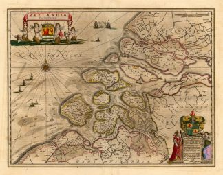
Map : ‘Zeelandia Comitatus.’ (Map of Zeeland.) Copper engraved contemp. hand coloured map of Zeeland, a province in the Netherlands. Cartouche above left with coat of arms, ships on the North Sea and a large cartouche bottom right with coat of arms. This map is by J. Janssonius after W. Blaeu. Latin text on verso. From ‘Atlas Novus’, published in Amsterdam, 1658 latin edition.Artists and Engravers: Johannes Janssonius also known as Jan Jansson was born 1588 in Arnhem, Netherlands. His father was a bookseller and publisher (Jan Janszoon the Elder). When he married the daughter of the cartographer Jodocus Hondius he also set up a business as book publisher in Amsterdam. His first map was published in 1616. Around 15 years later he set up a partnership with his brother in law Hondius add issued further editions of the Mercator/Hondius atlas. After his death in 1664, his heirs still have published several maps. Many of his plates have been acquired by Pieter Schenk and Gerard Valk.
Condition: Excellent. general age related toning. some light staining from handling. Rear latin text.
Keywords: ANTIQUE MAP-ZEELAND-NETHERLANDS-JANSSONIUS
XXX-B4-09

Reviews
There are no reviews yet.