


Description
Medium: Engraving, original hand-colored on hand laid (verge) paper.
Sheet size: 52 x 39 cm (20.47 x 15.35 inch). Image size: 50 x 36 cm. (19.69 x 14.17 inch).
Condition: good, given age. Slight discoloration and some minor stains, but overall in good condition with well-preserved coloring. General age-related toning and/or occasional minor defects from handling. Please study scan carefully.
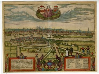
MAASTRICHT, 16TH CENTURY MAP, BRAUN & HOGENBERG, DUTCH CITY MAPS, CIVITATES ORBIS TERRARUM, HISTORICAL TOPOGRAPHY, EARLY CARTOGRAPHY, NETHERLANDS HISTORY | EXPO-MAPS-LARGE
BACKGROUND INFORMATION
Braun and Hogenberg, Civitates Orbis Terrarum vol.II, p.21, 1575.
Biography engraver: Georg Braun (1542-1622), a German publisher and Frans Hogenberg issued the famous six volume town book ‘Civitates Orbis Terrarum’ between 1572 and 1618. The volumes originally published in Latin, follow by German and French translations. The plates passed to Jan Janssonius who reissued the town books in 1657 while removing the costume figures on the plates. Franz Hogenberg (1533-1588) was the son of a Munich engraver who settled in Malines. He engraved most of the plates for Ortelius’ Theatrum and the majority of those in the Civitates, and may have been responsible for originating the project. Worked and died in Cologne/Germany. He was a prolific copper engraver and etching artist of maps and town views. In cooperation with Georg Braun he created the first four volumes of the Civitates Orbis Terrarum in 1572. The fifth and sixth volume was created by Simon van den Neuwel (Novellanus). This map was made by the Dutch cartographer Jan van Liefrinck, who was active in Leiden in 1567 and died there in 1599. He received payment on 22 August 1580 from the Leiden Magistracy for his map and view of the city, which was destined for Plantijn’s edition of Guicciardini’s Descrittione, 1581.
Biography artist: Simon de Bellomonte (1526-1615) was a canon of the St. Servatius Church in Maastricht and a skilled cartographer. He produced one of the earliest printed maps of Maastricht, which was later engraved and published by Braun & Hogenberg.

Reviews
There are no reviews yet.