


Description
Medium: Engraving on hand-laid (verge) paper.
Sheet size: 55.7 x 40 cm (21.93 x 15.75 inch). Image size: 43 x 34 cm. (16.93 x 13.39 inch).
Condition: very good, given age. Strong impression, crisp lines. Minor paper imperfections, small edge tears, and handling creases. Large margins. General age-related toning and/or occasional minor defects from handling. Please study scan carefully.
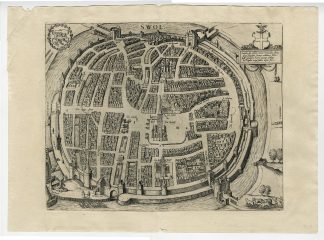
ZWOLLE, MEDIEVAL CITY MAP, BRAUN & HOGENBERG, HISTORICAL TOPOGRAPHY, DUTCH CITY VIEW, 16TH-CENTURY ENGRAVING, CIVITATES ORBIS TERRARUM | MAPS-LARGE
BACKGROUND INFORMATION
Published in Civitates Orbis Terrarum, Cologne, 1581, reissued 1640 by Peter von Brachel.
Reference: Van der Krogt Vol IV-2: 4976, David Rumsey Collection Ref: 12126.316.
Biography engraver: Simon Novellanus (d. 1590) and Joris Hoefnagel (1542-1600) were Flemish engravers and cartographers, contributing to Civitates Orbis Terrarum, one of the most significant city atlases of the Renaissance. Hoefnagel was known for his detailed illustrations and scientific accuracy, while Novellanus assisted in producing urban depictions of European cities.
Biography artist: Georg Braun (1541-1622) was a German topo-geographer and cleric, serving as the chief editor of Civitates Orbis Terrarum, the first systematic city atlas. Frans Hogenberg (1535-1590) was a Flemish-German engraver and mapmaker, responsible for engraving most of the maps in the atlas and collaborating on the famous Theatrum Orbis Terrarum.

Reviews
There are no reviews yet.