


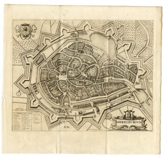
Description
Medium: Copper engraving on hand laid (verge) paper.
Sheet size: 60 x 50.5 cm (23.62 x 19.88 inch). Image size: 54 x 46.5 cm. (21.26 x 18.31 inch).
Condition: good, given age. Slight creasing along the edges, well-preserved original fold. General age-related toning and/or occasional minor defects from handling. Please study scan carefully.
ANTIQUE MAPS, NETHERLANDS, HOLLAND, SOUTH HOLLAND, DUTCH CARTOGRAPHY, 17TH-CENTURY MAPS, VISSCHER, HISTORICAL MAPS | MAPS-LARGE
BACKGROUND INFORMATION
Published by Nicolaes Visscher II, based on a 1651 wall map by Balthasar Florisz van Berckenrode. Printed before 1680, likely circa 1690. Originally part of the Atlas van Dirk van der Hagen.
Reference: KB catalogue, 353012750.
Biography engraver: Nicolaes Visscher II (1649-1702) was a Dutch engraver, cartographer, and publisher. He was the son of Nicolaes Visscher I and the grandson of Claes Janszoon Visscher. His widow, Elisabeth, continued the business after his death. Many of his works were later acquired and reprinted by Pieter Schenk.


Reviews
There are no reviews yet.