


Description
Engraving on wove paper. on paper.
Size in cm: The overall size is ca. 100.7 x 68.8 cm. The image size is ca. 96.2 x 62.7 cm. Size in inch: The overall size is ca. 39.6 x 27.1 inch. The image size is ca. 37.9 x 24.7 inch.
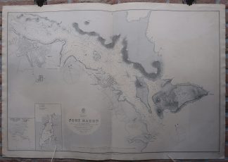
Antique map, titled: ”Mediterranean Minorca I. Port Mahon […].” – A detailed coastal chart of the harbour of Mahon on Menorca, one of the Baleares islands, and the immediate surroundings. Detailed depth soundings and two compass roses. Two inset maps in the lower left, one of the southern edge of the island, and another of the harbour of Fornells on the North coast of the island. Lighthouses are indicated with small coloured dots. Published by the Hydrographic Office of the Admiralty, 1891. Sold by J.D. Potter. Based on the Spanish Survey map of 1878 and with a few corrected editions.Artists and Engravers: Made by ‘Davies & Bryer’ after an anonymous artist.
Condition: Very good, given age. Original middle fold, as issued. Offsetting where the map was folded on itself. A few wormholes in the lower margin and lower edge of the image. General age-related toning and/or occasional minor defects from handling. Please study scan carefully.
Keywords: ANTIQUE MAP-SEA CHART-MENORCA-BALEARES-MAHON-OFFICE ADMIRALITY
(PCO) GK-187


Reviews
There are no reviews yet.