

Description
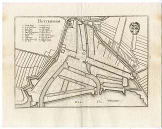
Rotterdam
Made by after an anonymous artist.
Medium: Engraving / Etching on hand laid (verge) paper.
Sheet size: 37.2 x 29.3 cm (14.65 x 11.54 inch). Image size: 31.2 x 21.3 cm. (12.28 x 8.39 inch).
Condition: very good, given age. Light foxing, soilng and creasing. Original middle fold as issued. General age-related toning and/or occasional minor defects from handling. Please study scan carefully.
ROTTERDAM | PCO-E14-19
BACKGROUND INFORMATION
Early in his life, he had created detailed town plans in his unique style, e.g. a plan of Basel (1615) and a plan of Paris (1615). With Martin Zeiler (1589?1661), a German geographer, and later (c.1640) with his own son, Matthaus Merian (der Jungere, i.e. “the Younger” or “Jr.”) (1621?1687), he produced a series of Topographia. The 21-volume set was collectively known as the Topographia Germaniae. It includes numerous town plans and views, as well as maps of most countries and a World Map it was such a popular work that it was re-issued in many editions. After his death, his sons Matthaus Jr. and Caspar took over the publishing house. They continued publishing the Topographia Germaniae and the Theatrum Europaeum under the name Merian Erben (i.e. Merian Heirs).
Biography engraver: Matthaus Merian der altere (or ‘Matthew’, ‘the Elder’, or ‘Sr.’; 1593-1650) was a Swiss-born engraver who worked in Frankfurt, Germany for most of his career, where he also ran a publishing house. He was a member of the patrician Basel Merian family.


Reviews
There are no reviews yet.