
 Print
Print Description
Copperplate engraving on a verge type hand laid paper. on paper.
Size in cm: The overall size is ca. 9 x 16.5 cm. The image size is ca. 7.5 x 14 cm. Size in inch: The overall size is ca. 3.5 x 6.5 inch. The image size is ca. 3 x 5.5 inch.
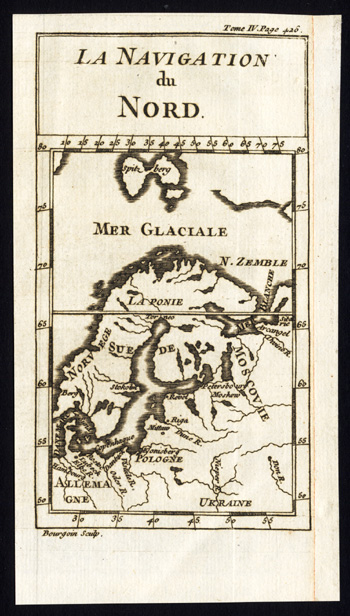
Map pag. 426: ‘La Navigation du Nord.’ (The navigation of the North). Map of Scandinavia and Russia. This original old antique print / plate originates from: ‘Le spectacle de la nature ou entretiens sur les particularites de l’histoire naturelle.’, by Noel Antoine Pluche and published in Paris by The Widow Estienne in 1742.Artists and Engravers: Noel-Antoine Pluche (1688 – 1761), known as the abbe Pluche, was a French priest. He is now known for his Spectacle de la nature, a most popular work of natural history. This plate engraved by Bourgoin.
Condition: Good. General age related toning. Narrow margin right side. remargined. Please study scan carefully.
Keywords: ANTIQUE MAP-NAVIGATION OF THE NORTH-SCANDINAVIA-RUSSIA-MUSCOVY-PLUCHE
PCOX-C6-16


Reviews
There are no reviews yet.