


Description
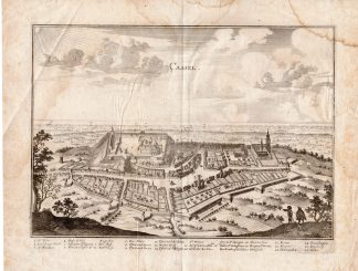
This hand coloured print shows the map of Mexico extending from just north of Mazatlan to Acapulco and from Tehuacan to the Sierra Madres, showing Mexico City, Puebla (Angelorum Civitas), Colima, Campostella, Purificatio and Mechoacan as the major cities of the time. Verso French text.
A highly ornate decorative map, with fabulous armorial title cartouche, sailing ships, compass rose and smaller cartouche. Not to be confused with the very similar Blaeu map of the same title.
Made by after an anonymous artist.
Medium: Engraving / hand coloured on hand laid (verge) paper.
Sheet size: 57 x 45.5 cm (22.44 x 17.91 inch). Image size: 48 x 35 cm. (18.9 x 13.78 inch).
Condition: good, given age. Brownish paper. Some brown spots. Paperloss in 2 corners. Some places thin paper because of insects. Fold as published. Tear in left margin restored. Wormhole left lower corner. General age-related toning and/or occasional minor defects from handling. Please study scan carefully.
MAP-MEXICO-SOUTH AMERICA | RBOS-T33-LARGE
BACKGROUND INFORMATION
This attractive print was published in Gerardi Mercatoris et I. Hondii – Atlas Novus, ca. 1636 by Iohan Iansson und Henderich Hondio. Joannes Janssonius (Arnhem, 1588-1664), son of the Arnhem publisher Jan Janssen, married Elisabeth Hondius, daughter of Jodocus Hondius, in Amsterdam in 1612. After his marriage, he settled down in this town as a bookseller and publisher of cartographic material. In 1618, he established himself in Amsterdam next door to Blaeu’s bookshop. He entered into serious competition with Willem Jansz. Blaeu when copying Blaeu’s Licht der Zeevaert after the expiration of the privilege in 1620. His activities concerned the publication of atlases, books, single maps, and an extensive book trade with branches in Frankfurt, Danzig, Stockholm, Copenhagen, Berlin, Koningsbergen, Geneva, and Lyon. In 1631, he began publishing atlases together with Henricus Hondius.
In the early 1640s, Henricus Hondius left the atlas publishing business to Janssonius. Competition with Joan Blaeu, Willem’s son and successor, in atlas production, prompted Janssonius to enlarge his Atlas Novus finally into a work of six volumes, into which a sea atlas and an atlas of the Old World were inserted. Other atlases published by Janssonius are Mercator’s Atlas Minor, Hornius’s historical atlas (1652), the townbooks in eight volumes (1657), Cellarius’s Atlas Coelestis and several sea atlases and pilot guides.
After the death of Joannes Janssonius, the shop and publishing firm were continued by the heirs under the direction of Johannes van Waesbergen (c. 1616-1681), son-in-law of Joannes Janssonius. Van Waesbergen added Janssonius’s name to his own.
In 1676, Joannes Janssonius’s heirs sold by auction ‘all the remaining Atlases in Latin, French, High and Low German, as well as the Stedeboecken in Latin, in 8 volumes, bound and unbound, maps, plates belonging to the Atlas and Stedeboecken.’ The copperplates from Janssonius’s atlases were afterwards sold to Schenk and Valck.
Biography engraver: Jodocus Hondius the Elder (1563-1612), or Joost de Hondt, was one of the most prominent geographers and engravers of his time. His work did much to establish Amsterdam as the center of cartographic publishing in the seventeenth century. Born in Wakken but raised in Ghent, the young Jodocus worked as an engraver, instrument maker, and globe maker.
Hondius moved to London in 1584, fleeing religious persecution in Flanders. There, he worked for Richard Hakluyt and Edward Wright, among others. Hondius also engraved the globe gores for Emery Molyneux’s pair of globes in 1592; Wright plotted the coastlines. His engraving and nautical painting skills introduced him to an elite group of geographic knowledge seekers and producers, including the navigators Drake, Thomas Cavendish, and Walter Raleigh, as well as engravers like Theodor De Bry and Augustine Ryther. This network gave Hondius access to manuscript charts and descriptions which he then translated into engraved maps.
In 1593 Hondius returned to Amsterdam, where he lived for the rest of his life. Hondius worked in partnership with Cornelis Claesz, a publisher, and maintained his ties to contacts in Europe and England. For example, from 1605 to 1610, Hondius engraved the plates for John Speed’s Theatre of the Empire of Great Britaine.
One of Hondius’ most successful commercial ventures was the reprinting of Mercator’s atlas. When he acquired the Mercator plates, he added 36 maps, many engraved by him, and released the atlas under Mercator’s name, helping to solidify Mercator’s reputation posthumously. Hondius died in 1612, at only 48 years of age, after which time his son of the same name and another son, Henricus, took over the business, including the reissuing of the Mercator atlas. After 1633, Hondius the Elder’s son-in-law, Johannes Janssonius, was also listed as a co-publisher for the atlas.

![[Hubertus QUELLINUS] Ornamental decoration: masks, spinning, agriculture (Amsterdam City Hall)](https://pictura-prints.com/wp-content/uploads/2018/07/pcom_0330-324x483.jpg)


Reviews
There are no reviews yet.