


Description
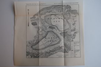
Large plate with 6 maps dealing with Indonesia. Map of Halmahera, Maluku Islands – Kai or Kei Islands, Moluccas – North Borneo Company area – etc.
Made by an anonymous engraver after Aardr. Genootschap.
Medium: Lithograph on wove (vellin) paper.
Image size: 66 x 23.3 cm. (25.98 x 9.17 inch).
Condition: good, given age. Original folds as issued. General age-related toning and/or occasional minor defects from handling. Please study scan carefully.
INDONESIA-MOLUCCAS-HALMAHERA-KAI-KEI | PCO-B5-33
BACKGROUND INFORMATION
Source: ‘Tijdschrift van het Koninklijk Nederlandsch Aardrijkskundig Genootschap’, a periodical published from 1888-1966, initially published by C.F. Stemler and later by Brinkman/Beijers (from 1879) and Brill (from 1891). This item dates from 1888.
. . Asia.


Reviews
There are no reviews yet.