

Description
Copperplate engraving on a vellin type paper. Recent hand colouring. on paper.
Size in cm: The overall size is ca. 24 x 21 cm. The image size is ca. 28 x 19 cm. Size in inch: The overall size is ca. 9.4 x 8.3 inch. The image size is ca. 11 x 7.5 inch.
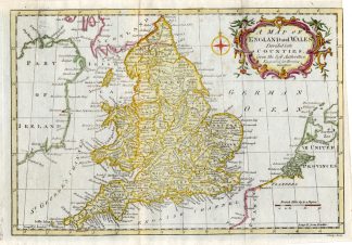
Map: England and Wales. This map shows: England and Wales, Ireland, Scotland, Irish Sea, Isle of Man, Cornwall, Essex, Kent, Devon, York, Norfolk, Suffolk, etc. This engraved map originates from: ‘General Gazetteer … by Richard Brookes.Artists and Engravers: The author of this work is Richard Brookes MD. The map is engraved by J. Lodge.
Condition: Fine. General age related toning and occasional light staining from handling as visible on image. Some false fold lines as typical from binding and handling..
Keywords: ANTIQUE MAP-GREAT BRITAIN-ENGLAND-WALES-MAN-BROOKES
XXX-A2-25


Reviews
There are no reviews yet.