


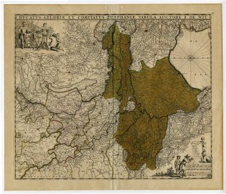
Description
Medium: Copper engraving with later hand coloring on hand-laid (verge) paper.
Sheet size: 58.5 x 49 cm (23.03 x 19.29 inch). Image size: 55.5 x 46 cm. (21.85 x 18.11 inch).
Condition: very good, given age. Light foxing, creasing and soiling. Original vertical fold as issued. General age-related toning and/or occasional minor defects from handling. Please study scan carefully.
GELDERLAND, ZUTPHEN, ANTIQUE MAP, DE WIT MAP, DUTCH CARTOGRAPHY, 17TH-CENTURY NETHERLANDS, HISTORICAL MAPS, GELDERSE REGIO, NETHERLANDS PROVINCE MAPS | MAPS-NETHERLANDS-OVERSIZE
BACKGROUND INFORMATION
Published by Frederik de Wit, c. 1690.
Biography engraver: Frederik de Wit (c. 1629-1706) was a Dutch cartographer and publisher known for his high-quality maps and atlases. His works were among the most respected in 17th-century Amsterdam, and his atlases featured detailed maps of Europe and the world.


Reviews
There are no reviews yet.