


Description
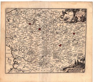
This print shows a view on a map of Artesia, Nord-Pas-de-Calais, France. Villages are shown, including a network of roads, rivers, forests, etc. With Grevelinge, Calais, Saint-Omer, Arras, Douai, Boulogne-sur-Mer, and many more.
Made by an anonymous engraver/artist.
Medium: Engraving with contemporay hand hand colouring on hand laid (verge) paper.
Sheet size: 20.7 x 18 cm (8.15 x 7.09 inch). Image size: 18 x 14.8 cm. (7.09 x 5.83 inch).
Condition: good, given age. Fold as published. Creases. Brown paper. Folds in upper corners. General age-related toning and/or occasional minor defects from handling. Please study scan carefully.
MAP-FRANCE-NORD PAS DE CALAIS-ARRAS-DOUAI-BOULONGE SUR MER | RBOS-A10-28
BACKGROUND INFORMATION
This print was published ca 1700.


Reviews
There are no reviews yet.