

 Print
Print Description
Engraving on handlaid (verge type) paper. Watermark: Letters (to be deciphered). on paper.
Size in cm: The overall size is ca. 91.5 x 62 cm. The image size is ca. 88.5 x 57.5 cm. Size in inch: The overall size is ca. 36 x 24.4 inch. The image size is ca. 34.8 x 22.6 inch.
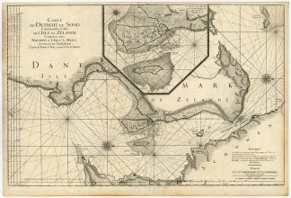
Antique map, titled: ‘Carte du detroit du Sond contenant les costes de l’Isle de Zelande comprises entre Nicopen et l’Isle de Meun, et celles du Schonen depuis la Pointe de Kol, jusqu’a Valsterbon […]’ – (Map of Street of the Sond, containing the coasts of the island of Zeeland …) Fine large overview coastal map / seachart of The Sond between Seeland, Denmark and Schonen, Sweden with a large inset “Carte de la Rade de Copenhague et des Environs”. (Inset map of Copenhagen and surroundings.) From: ‘La Neptune Francois […]’, by Jaillot, published in Amsterdam by Pieter Mortier. First published in 1693 as a result of an initiative by the minister Colbert. State: Only state. Ref: Koeman M. Mor 1, map 4. Original full size Atlas sheet.Artists and Engravers: Made by an anonymous engraver after ‘Alexis Hubert Jaillot’. Cartographer: Alexis-Hubert Jaillot (1632-1712), was a French cartographer. He married the daughter of the ‘enlumineur de la Reine’, Nicholas Berey and inherited thus a map and print publishing firm. When Nicolas Sanson, the premier French cartographer of his days, died he negotiated to republish much of his work. He re-published many of Sanson’s maps on a larger scale. His maps were admired for their beautiful cartouches. In 1686 he was awarded the title of Geographe du Roi by Louis XIV. Jailliot was succeed by his son, Bernard Jean Hyacinthe Jaillot (1673-1739), grandson, Bernard Antoine Jaillot (died 1749) and the latter’s brother-in-law, Jean Baptiste-Michel Renou de Chauvigne-Jaillot (1710-1780). Publisher: Pieter / Pierre Mortier (1661-1711). The 18th century Dutch map trade could build on their reputation that originated from the Golden Age much longer than was assumed until now. The Amsterdam publishing company Covens & Mortier (1685-1866) has played an important part in this process. Most likely this company was the largest map trader of his days. Thousand of maps were brought on the market by Covens & Mortier, often edited from earlier sources and all members of this firm were gifted with a great commercial talent. Pieter and David Mortier were booksellers in Paris from 1681-1685 and have published a wide range of geographical works. After Pieter’s death, his widow continued the business until their son Cornelius took over in 1721. Cornelius started a partnership with his brother-in-law Johannes / Jean Covens and established the famous publishing house “Covens and Mortier” in Amsterdam. They have re-issued Atlases of Sanson, de l’Isle, Visscher and de Wit.
Condition: Very good, given age. Original middle fold as issued. Middle fold partly separated, but restored and backed. Light soiling. A few small tears in paper edges. Some stains. Some creasing. General age-related toning and/or occasional minor defects from handling. Please study scan carefully.
Keywords: ANTIQUE MAP-DENMARK-SOUND-SOND-COPENHAGEN-SEACHART-JAILLOT-MORTIER
(PCO) ZH-430


Reviews
There are no reviews yet.