

Description
Engraving on hand laid (verge) paper. on paper.
Size in cm: The overall size is ca. 35 x 32.5 cm. The image size is ca. 34 x 28.3 cm. Size in inch: The overall size is ca. 13.8 x 12.8 inch. The image size is ca. 13.4 x 11.1 inch.
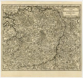
Antique print, titled: ‘Nieuwe Kaart van het Hertogdom Brabant, Limburg en Opper Gelder.’ – (New Map of the Duchy of Brabant, Limburg and Gelderland.) Detailed map covering Gelderland, Brabant and Limburg in the Netherlands and Belgium. Published in Amsterdam by Isaak Tirion in 1738. Artists and Engravers: Made by an anonymous engraver after ‘Isaak Tirion’. Isaak Tirion, a Dutch publisher in Amsterdam, was born 1705. He produced serveral Atlases and Dutch town plans. The maps mainly based on those of Guillaume de l’Isle. He died in 1765.
Condition: Excellent, given age. Original folds, as issued. General age-related toning and/or occasional minor defects from handling. Please study scan carefully.
Keywords: ANTIQUE MAP-BRABANT-LIMBURG-NETHERLANDS-BELGIUM-TIRION
PCOX-E1-30


Reviews
There are no reviews yet.