


Description
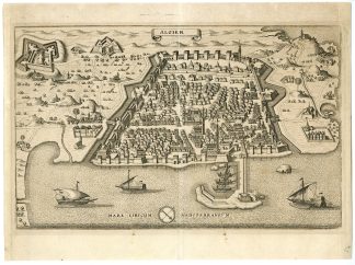
Medium: Copper engraving on hand-laid (verge) paper.
Sheet size: 32.7 x 38.1 cm (12.87 x 15 inch). Image size: 22 x 34.6 cm. (8.66 x 13.62 inch).
Condition: good, given age. Light foxing, creasing and soiling. Original vertical fold as issued. . General age-related toning and/or occasional minor defects from handling. Please study scan carefully.
ALGIERS, ALGIER, ANTIQUE MAP, MATTH?US MERIAN, 17TH-CENTURY MAP, OTTOMAN ALGIERS, HISTORICAL CARTOGRAPHY, AFRICA MAP, MEDITERRANEAN PORTS, FORTIFIED CITIES | PCO-E19-47
BACKGROUND INFORMATION
From Neuwe Archontologia Cosmica, published by Johann Ludwig Gottfried, 1646.
Reference: 10595.
Biography engraver: Matth?us Merian the Elder (1593-1650) was a Swiss engraver, publisher, and cartographer known for his highly detailed city views and maps. He studied in Zurich and worked for Johann Theodor de Bry, eventually completing and publishing de Bry’s Grand Voyages and Petit Voyages. Merian’s most famous works include the Topographia series, a 21-volume collection of European city views and maps, which were later continued by his sons. His historical engravings remain among the most detailed and sought-after cartographic works of the 17th century.

Reviews
There are no reviews yet.