

Description
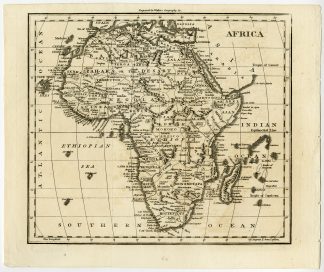
Copperplate engraving on a vellin type paper. Recent hand colouring. on paper.
Size in cm: The overall size is ca. 25.1 x 21 cm. The image size is ca. 20.9 x 18.7 cm. Size in inch: The overall size is ca. 9.9 x 8.3 inch. The image size is ca. 8.2 x 7.4 inch.
Map: Africa. This map shows: Zahara, Desart, Dessert, South Africa, Madagascar, Monomotapa, Angola, Benguela, Negolan, Guinea, Adel, Ajan, Morocco, Tunesia, Algeria, Libya, Mauritania, Mali, Niger, Nigeria, etc. This engraved map originates from: ‘Universal Gazetteer … by John Walker / Arthur Kershaw, London, fifth edition, 1810.Artists and Engravers: The author of this work is John Walker, M.D. The maps are engraved by William Darton Jr., who was active in London in his father’s publishing house from the late 18th. c. This map was originally engraved for the Atlas to Walker’s Geography.
Condition: Excellent. Original folds, as issued. Binding holes in right margin. General age-related toning and occasional light stains from handling. Please study image carefully.
Keywords: ANTIQUE MAP-AFRICA-HOTTENTOTS-EGYPT-NUBIA-WALKER
XXX-A2-27


Reviews
There are no reviews yet.