


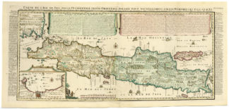
Description
Medium: Copper engraving, hand-colored on hand laid (verge) paper.
Sheet size: 56 x 47 cm (22.05 x 18.5 inch). Image size: 54 x 42.5 cm. (21.26 x 16.73 inch).
Condition: good, given age. Some small edge tears, original hand-coloring, original center fold. General age-related toning and/or occasional minor defects from handling. Please study scan carefully.
ANTIQUE MAPS, BRABANT, NETHERLANDS, ‘S-HERTOGENBOSCH, DUTCH CARTOGRAPHY, 17TH-CENTURY MAPS, HONDIUS, HISTORICAL MAPS | MAPS-LARGE
BACKGROUND INFORMATION
Published in Gerardi Mercatoris Et I. Hondii. Atlas, Amsterdam, 1636. Printed by Henricus Hondius and Johannes Janssonius.
Reference: Koeman (1967-1971) II, 376, (5).
Biography engraver: Henricus Hondius (1597-1651) was a Dutch engraver, cartographer, and publisher, son of Jodocus Hondius. He continued his father’s map-making legacy, working with Johannes Janssonius to expand the Mercator-Hondius Atlas.


Reviews
There are no reviews yet.