


Description
Medium: Etching and engraving, hand-colored on hand-laid (verge) paper.
Sheet size: 60.3 x 50.3 cm (23.74 x 19.8 inch). Image size: 53.6 x 42.5 cm. (21.1 x 16.73 inch).
Condition: very good, given age. Slight age-toning and some minor creasing, well-preserved coloring, strong impression. Original vertical fold as issued. General age-related toning and/or occasional minor defects from handling. Please study scan carefully.
BRABANT, MEIERIJ VAN ‘S-HERTOGENBOSCH, HISTORICAL MAPS, 17TH-CENTURY CARTOGRAPHY, DUTCH GOLDEN AGE, ANTIQUE MAPS, FREDERIK DE WIT, ATLAS MAPS, ENGRAVED MAPS | EXPO-MAPS-LARGE
BACKGROUND INFORMATION
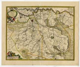
Published by Frederik de Wit in Amsterdam, 1689-1690. The first state was used in various atlases by Hondius and Janssonius. This edition was later included in De Wit’s atlases. A finely detailed and colored map of the Meierij van ‘s-Hertogenbosch.
Reference: Koeman’s Atlantes Neerlandici; Frederik de Wit and the first concise reference atlas; Collectie Rijksmuseum 1(2).
Biography engraver: Unknown engraver, likely working under Frederik de Wit’s supervision. De Wit often commissioned talented engravers for his maps, though their names were not always credited.
Biography artist: Frederik de Wit (c. 1629-1706) was a Dutch cartographer and publisher based in Amsterdam. His works included atlases, maps, and town plans. He was known for acquiring and republishing maps from earlier cartographers, often improving them with artistic embellishments. His firm was a leading force in 17th-century cartography.


Reviews
There are no reviews yet.