


Description
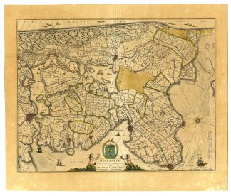
Medium: Engraving with original hand coloring on hand-laid (verge) paper.
Sheet size: 55 x 47 cm (21.65 x 18.5 inch). Image size: 49.2 x 38.4 cm. (19.37 x 15.12 inch).
Condition: very good, given age. Middle fold as published. Light foxing, creasing and soiling. Overall browning. General age-related toning and/or occasional minor defects from handling. Please study scan carefully.
NOORD HOLLAND, WEST FRIESLAND, ANTIQUE MAP, BLAEU MAP, AMSTERDAM, MEDEMBLIK, ENKHUIZEN, ALKMAAR, HOORN, DUTCH POLDER MAP, HISTORICAL CARTOGRAPHY, 17TH-CENTURY MAPS | MAPS-NETHERLANDS -OVERSIZE
BACKGROUND INFORMATION
Published by Willem Jansz and Joan Blaeu, c. 1640.
Biography engraver: Willem Jansz Blaeu (1571-1638) was a leading Dutch cartographer and publisher. His son, Joan Blaeu (1596-1673), continued the family’s work and expanded their atlas series, including the famous Atlas Maior.

![PLAN-LODGE-BARSALOOR-KANARA-INDIA [After VALENTIJN-VOC, 1724]](https://pictura-prints.com/wp-content/uploads/2019/03/pco-4168-324x516.jpg)


Reviews
There are no reviews yet.