

Description
Lithograph on thin wove paper. on paper.
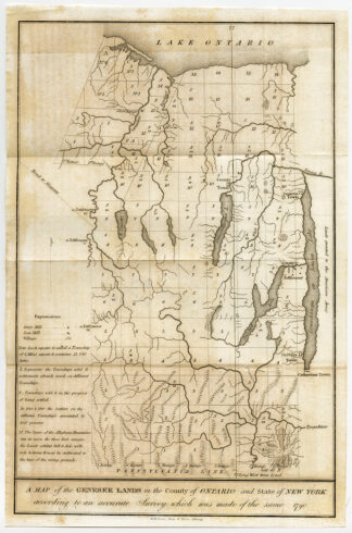
Size in cm: The overall size is ca. 22.3 x 33.8 cm. The image size is ca. 20.9 x 32.1 cm. Size in inch: The overall size is ca. 8.8 x 13.3 inch. The image size is ca. 8.2 x 12.6 inch.
Antique print, titled: ‘A map of the Genesee Lands in the County of Ontario and State of New York according to an accurate Survey which was made of the same 1790.’ – A map of the area south of Ontario Lake, until Tioga river. Locations of early settlements and townships are given, as well as rivers, lakes and mountain ranges. Based on a 1790 Survey. This is a lithographically made map from ca. 1849. “Maps in the offices of Secr. Of State and Surveyor General”, Albany: Richard H. Pease, ca. 1850. Cartographers were David Vaughan, E.O. Olmsted and M.E. Seymour.Artists and Engravers: Made by ‘Richard H. Pease’ after an anonymous artist. Printer / publisher: Richard H. Pease (1813-1869) was an engraver / lithographer and printer from Albany.
Condition: Good, given age. Original folds as issued. Some small stains, the sheet partly browned. Crease in the left top margin. General age-related toning and/or occasional minor defects from handling. Please study scan carefully.
Keywords: ANTIQUE PRINT-GENESEE LANDS-LAKE ONTARIO-USA-PEASE
(PCO) C130-24

Reviews
There are no reviews yet.