

Description
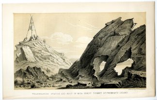
‘West end of Fremont`s Iand Promontory Range looking north G. S. Lake.’
Crayon and tone lithograph on wove (vellin) paper.
Sheet size: 22,5 x 14,5 cm. (8,9 x 5,7 inch). Image size: 19,5 x 11,5 cm. (7,7 x 4,5 inch).
From ‘Exploration and survey of the valley of the Great Salt Lake of Utah ?’, by Howard Stansbury, published by Lippintott, Grambo & Co., 1852. Ref: This is one of the great US Government exploration reports of the American West, and a must for any serious collector of exploration or Western Americana. ‘Stansbury’s Report along with Gunnison’s book, The Mormons, provided the outside world with an objective look at the Mormons of Utah as well as with a scientific appraisal of the resources and fauna and flora of this section of the Great Basin.’ – Brigham D. Madsen. Flake/Draper 8359. Wagner/Camp 219:2.
Made by ‘Ackerman’ after ‘(Author: Howard Stansbury)’. Howard Stansbury (1806-1863) was a Captain in the US Army Corps of Topographical Engineers at the time of this expedition. He was assigned to lead a two year expedition in 1849 to survey the Great Salt Lake and surrounding Basin of Mormon settlements. Lt. Gunnison was also part of the expedition and led separate surveys of the area. This was part of the Great Reconnoissance era of Army and private surveys of the West. Stansbury’s report was a comprehensive survey of the Great Salt Lake Basin, the newly established Mormon settlements, the routes and passes through the Rockies for emigrants and possibly a railroad. This was the first scientific exploration of the flora and fauna of the area. The recording the early names of the places and routes on the maps are one of the earliest and most important to preserve details.
Condition: Good, given age. Light text ghosting from opposite page. Minor damp stains right margin, not affecting image. General age-related toning and/or occasional minor defects from handling. Please study scan carefully.
Keywords: SALT LAKE-UTAH-PROMONTORY-FREMONT ISLAND
PCO-C24-19

![Pl. I-Terra del Fuego natives-hut [J.S. KLAUBER after COOK, 1795]](https://pictura-prints.com/wp-content/uploads/2019/01/pco-2674-324x255.jpg)


Reviews
There are no reviews yet.