

Description
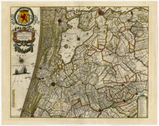
Subject: Antique print, titled: ‘Rhenolandiae et Amstellandia.’ – This maps shows a Rijnland and Amstelland in the provinces North and South Holland in the Netherlands. This includes Haarlem, Amsterdam, Utrecht, Gouda, Leyden and The Hague.
Condition: Very good, given age. Original middle fold, as issued. Middle fold reinforced using contemporary paper. Print has been in matting, some ghosting around the image. General age-related toning and/or occasional minor defects from handling. Please study scan carefully.
Medium: Hand colored engraving on hand laid paper.
Size (in cm): The overall size is ca. 56.2 x 44.7 cm. The image size is ca. 50 x 40.8 cm.
Size (in inch): The overall size is ca. 22.1 x 17.6 inch. The image size is ca. 19.7 x 16.1 inch.
Part Number: 52569
Location: PCO-P3-16 / Expo-161
Description: Published in Amsterdam in 1649 by Willem Jansz. Blaeu in ‘Toonneel des Aerdrycx, oft Nieuwe Atlas.’, a Dutch ed of: ‘Theatrum Orbis Terrarum, sive Atlas Novus’; in quo Tabulae et Descriptiones omnium Regionum. Rear text Dutch.
Artists and Engravers: Willem Janszoon Blaeu was born 1571 in Alkmaar. He was trained from 1594 to 1596 by the famous danish astronomer Tycho Brahe. 1599 he went to Amsterdam and founded a business as globe maker. Later he started producing map and sea charts, including his first world map in 1605. In 1633 he was appointed Hydrographer for the Dutch East India Company (VOC). His most famous work was the “Atlas Novus” or “Theatrum Orbis Terrarum sive Atlas Novus” of 1635, which was published until 1655 in total six volumes. After Blaeu’s death in 1638 his sons Joan and Cornelis continued the businees and finished the “Atlas Novus” and started an even larger work, the “Atlas Maior”, which reached 12 volumes. In 1672 a fire destroyed the printing house and a year later Joan died. Some of the surviving plates where bought by F. de Wit and Schenk & Valk. The business was closed finally in 1695.


Reviews
There are no reviews yet.