

Description
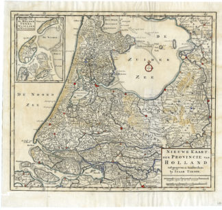
‘Nieuwe Kaart der Provincie van Holland’
Etching / engraving with remains of hand colouriing on hand laid (verge) paper.
Sheet size: 40,5 x 37,5 cm. (15,9 x 14,8 inch). Image size: 37,5 x 33 cm. (14,8 x 13 inch).
Source unknown, published by Tirion.
Made by an anonymous engraver after ‘Isaac Tirion’. Isaak Tirion, a Dutch publisher in Amsterdam, was born 1705. He produced serveral Atlases and Dutch town plans. The maps mainly based on those of Guillaume de l’Isle. He died in 1765. Engraver unknown.
Condition: Good, given age. Strip of paper on rear for unknown reasons, firmly attached. Bottom left plate edge separated, but backed. Rear blank. General age-related toning and/or occasional minor defects from handling. Please study scan carefully.
Keywords: HOLLAND-NETHERLANDS-UTRECHT-TEXEL
CONS-B1-32


Reviews
There are no reviews yet.