


Description
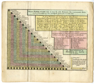
‘Nieuwe Steede-wyzer waar in men de nette distantie der voornaamste Steeden in de 17 Provintien op 800 verschydene wysen sien en weten kan.’
Engraving with original hand colouring on hand laid paper.
Sheet size: 22,9 x 20,3 cm. (9 x 8 inch). Image size: 19,5 x 16,5 cm. (7,7 x 6,5 inch).
From: ‘Nieuwe Astronomische Geographische en Historische Atlas …’, by Jean Rousset de Missy, published in Amsterdam by Hendrik de Leth, not dated, but 1749, rare extended 1st. Dutch edition. From 1770 onwards it was published by S.J. Baalde (cf. Koeman Baa 1A and Baa 1B).
Anonymous.
Condition: Good, given age. Original folds as issued. Ppaper edges with some browning and chipping. General age-related toning and/or occasional minor defects from handling. Please study scan carefully.
Keywords: DISTANCE TABLE-NETHELANDS-BELGIUM
RBOS-A3-27 (RB-249)

Reviews
There are no reviews yet.