

Description
Original colour lithograph on a vellin type paper. on paper.
Size in cm: The overall size is ca. 24 x 15.5 cm. The image size is ca. 21 x 14 cm. Size in inch: The overall size is ca. 9.4 x 6.1 inch. The image size is ca. 8.3 x 5.5 inch.
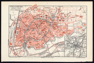
Plan: ‘Strassburg’ (Strasbourg), with a small inset of the surrounding region. This attractive original old antique print / plate / map originates from 1885-1907 editions of a famous German encyclopedia: ‘Meyers grosses Konversations-Lexikon.’, published in Leipzig and Vienna. Meyers Konversations-Lexikon was a major German encyclopedia that existed in various editions from 1839 until 1984, when it merged with the Brockhaus encyclopedia. Several of the plates were also used in Dutch Encyclopedia’s like Winkler Prins. Please see the details in the Title to ascertain from which specific edition this plate originates.Artists and Engravers: The original founder and publisher who initiated this famous encyclopedia was Joseph Meyer (1796-1856, Hildburghausen, Germany).
Condition: Very good. Bottom edge uneven from binding, top left edge creased (not affecting image). General age-related toning and/or light stains from handling. Please study scan carefully.
Keywords: ANTIQUE PLAN-STRASBOURG-FRANCE-MEYERS
(PCOMAN) A174-03

Reviews
There are no reviews yet.