


 Print
Print Description
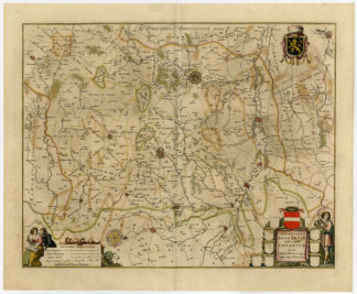
This print shows a map of the Theater of War in Austrian and French Flanders, corresponding to a large part of the territory of present-day Belgium and north-western France. The reference is to the campaign in Flanders, fought victoriously in these territories by French revolutionary troops against a broad coalition.
Made by an anonymous engraver after Zatta.
Medium: Engraving wiht hand colouring on handlaid (verge) paper.
Sheet size: 45 x 35.5 cm (17.72 x 13.98 inch). Image size: 36.5 x 28.5 cm. (14.37 x 11.22 inch).
Condition: good, given age. Folds as published. Three diagonal folds. Tears in margin folds restored. Corner strenghened. Creases. General age-related toning and/or occasional minor defects from handling. Please study scan carefully.
WAR-AUSTRIA-FRENCH FLANDERS-BELGIUM-NW FRANCE | RB-A8-33
BACKGROUND INFORMATION
This attractive print was published in ‘Prospectus of the Current Affairs of Europe or History of War.’ This work was begun by the historian Domenico Caminer, published in Venice, by Antonio Zatta and Suns. Although the false headquarters of Lugano is indicated, in 41 volumes of small format adorned with 97 between maps and portraits.




Reviews
There are no reviews yet.