
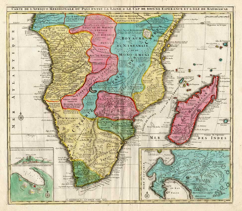
Description
Engraved map with original contemporary hand colouring, printed on a verge type hand laid paper. on paper.
Size in cm: The overall size is ca. 66 x 56 cm. The image size is ca. 58 x 51 cm. Size in inch: The overall size is ca. 26 x 22 inch. The image size is ca. 22.8 x 20.1 inch.
Original decorative large map titled: ‘Carte de l’Afrique meridionale ou pays entre la ligne et le cap de Bonne Esperance et l’isle de Madagascar. Chez Ian Barend Elwe … 1792.’ This map shows the south of Africa, with South Africa, Madagascar, Tanzania, Botswana, Congo, Namibia, Zimbabwe, Mozambique, Zambia, Gabon, Uganda and Kenya This map has inserts of Cap de Bonne Esperance (Cape of Good Hope), Cape Town, Table Mountain. This original map originates from an Atlas published in 1793 by J.B. Elwe. Artists and Engravers: The author of this atlas is Jan Barend Elwe (1774-1815), a Amsterdam bookseller. Ref: Koeman, Atlantes Neerlandici Vol. II, S. 105, El 2, 2. Tooley’s Dict. of Mapmakers.
Condition: Fine. General light age related toning, some false fold lines, as visible on scans. Map differs slightly from the illustrated image as it is merged from several scans.
Keywords: ANTIQUE MAP-SOUTH AFRICA-TANZANIA-MADAGASCAR-ELWE
XXX-B1-08

Reviews
There are no reviews yet.