
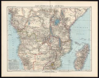
Description
Colour lithograph on a vellin type paper. on paper.
Size in cm: The overall size is ca. 56.4 x 44.3 cm. The image size is ca. 49.6 x 37.6 cm. Size in inch: The overall size is ca. 22.2 x 17.4 inch. The image size is ca. 19.5 x 14.8 inch.
Map : ‘Aquatoriales Afrika’. Map of Central Africa, showing Madagascar, Congo, and various German and British colonies. This map from E. Debes’ Neuer Handatlas, ca. 1895.Artists and Engravers: The author of this atlas is Ernst Debes (1840-1923).
Condition: Excellent. Original middle fold as issued. General age related toning and slight soiling. Please study scan carefully.
Keywords: ANTIQUE MAP-SOUTH AFRICA-MADAGASCAR-ANDREE-1904
XXX-B2-15


Reviews
There are no reviews yet.