


Description
Engraving on hand laid paper. on paper.
Size in cm: The overall size is ca. 99.3 x 66.4 cm. The image size is ca. 86.4 x 58.7 cm. Size in inch: The overall size is ca. 39.1 x 26.1 inch. The image size is ca. 34 x 23.1 inch.
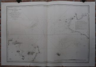
Antique map, titled: ”Carte du Passage entre la Sicilie et l”Afrique […].” – A sea chart of the Mediterranean, showing the South of Sicily in the right edge of the map (Palermo at the far edge) and the coast of North Africa (Tunesia) in the lower left. Also includes the island Pantelleria. Shows depth soundings, location of sand banks and geographical features along the shore. Published by the Depot de la Marine, dated 1843. The text by J. Hacq.Artists and Engravers: Made by ‘Jacobs’ after ‘Mr. Bonard ao.’. Depot des Cartes et Plans de la Marine (1720 – present), often called the Depot de Marine, was a French hydrographic mapping organization founded in 1720. Much like the U.S. Coast Survey, the British Admiralty, and the Spanish Deposito Hydrografico, the Depot was initiated as a storehouse and distribution center of existing nautical and marine charts. Eventually the Depot initiated its on mapping activities in an attempt to improve and expand upon existing material. Some of the well known hydrograhers / cartographers in the development of Depot were Jacques Nicholas Bellin and Riobert Bonne.
Condition: Very good, given age. Original middle fold, as issued. Offsetting where the map was folded on itself. A few small creases and faint stains in the margins. General age-related toning and/or occasional minor defects from handling. Please study scan carefully.
Keywords: ANTIQUE MAP-SEA CHART-SICILY-TUNESIA-PANTELLERIA-DEPOT DE LA MARINE
(PCO) GK-195

Reviews
There are no reviews yet.