


Description
Engraving on hand laid paper. on paper.
Size in cm: The overall size is ca. 59.7 x 51.9 cm. The image size is ca. 56 x 44.4 cm. Size in inch: The overall size is ca. 23.5 x 20.4 inch. The image size is ca. 22 x 17.5 inch.
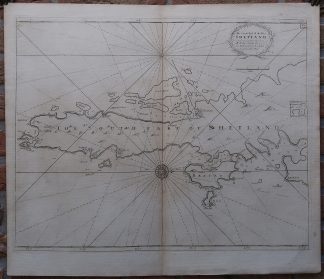
Antique map, titled: ‘The South Part of the Isles of Shetland …’ – A map of the southern part of the Shetland islands, showing Mainland Shetland, East Burra, Mousa, Bressay and several smaller islands. Coastal towns are indicated, as well as depth soundings along the coast. A small inset in the right edge of the map extends the map area toward Catfirth. Greenville Collins’ map from “Great Britain’s Coastal Pilot”. This nautical atlas was originally published in 1693, and reprinted numerous times until the nineteenth century. We are unsure from which exact edition this map is.Artists and Engravers: Made by an anonymous engraver after ‘Greenville Collins’. Capt. Greenville Collins (1643-1694). Collins was an officer of the Royal Navy and prominent hydrographer, who was commissioned by King Charles II in 1676 and appointed by Samuel Pepys (then Secretary to the Admiralty), to chart the coasts of Great Britain. The resulting atlas – Great Britain’s Coasting Pilot – was the first original sea atlas to be produced by an Englishman.
Condition: Very good, given age. Original middle fold, as issued. Faintly browned in the middle fold. A crease and small stain in the right margin. Very faint offsetting from being folded. General age-related toning and/or occasional minor defects from handling. Please study scan carefully.
Keywords: ANTIQUE MAP-SEA CHART-SHETLAND ISLANDS-BURRA-MOUSA-BRESSAY-COLLINS
(PCO) GK-319


Reviews
There are no reviews yet.