


Description
Engraving on hand laid paper. Watermark: J. Kool C & W Comp. on paper.
Size in cm: The overall size is ca. 101.8 x 68.3 cm. The image size is ca. 89.8 x 59.8 cm. Size in inch: The overall size is ca. 40.1 x 26.9 inch. The image size is ca. 35.4 x 23.5 inch.
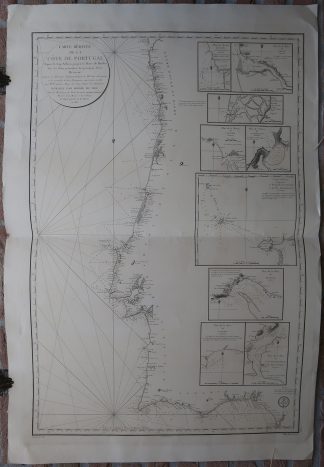
Antique map, titled: ‘Carte Reduite de la Cote de Portugal, Depuis le Cap Silleiro jusqu’a la Barre de Huelba.’ – A sea chart of the Portuguese coast, from Sanlucar de Barrameda (Spain) to Vigo. This area includes Lissabon, Porto, Lagos and Albufeira. This map shows villages and geographical features along the coast. Depth soundings are shown along the coast. Nine inset maps show parts of the coast in greater detail, these include the area around Setubal, Lagos, Porto, Portimao, Berlengas, and others. By M. Frazini for the Depot de la Marine.Artists and Engravers: Made by ‘E. Collin’ after ‘M. Frazini’.
Condition: Very good, given age. Original middle fold, as issued. Some offsetting where the map was folded on itself. Some small imperfections (creasing in the corners and small nicks) in the margin edges. General age-related toning and/or occasional minor defects from handling. Please study scan carefully.
Keywords: ANTIQUE MAP-SEA CHART-PORTUGAL-LISSABON-PORTO-VIGO-DEPOT DE LA MARINE
(PCO) GK-081

Reviews
There are no reviews yet.