


Description
Engraving on wove paper. on paper.
Size in cm: The overall size is ca. 123.5 x 67.2 cm. The image size is ca. 120 x 64.3 cm. Size in inch: The overall size is ca. 48.6 x 26.5 inch. The image size is ca. 47.2 x 25.3 inch.
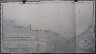
Antique map, titled: ”Mediterranean Sea Egypt – Ras Bulau to Alexandria.” – A coastal chart of Egypt, from ca. Sidi Barrani/Marsa Matruh to Alexandria. Depth soundings along the coast and three compass roses. A few inland geographical details. Three coast profiles lower left, above five inset detial maps of specific places along the coast. A few lighthouses are indicated with coloured dots, mostly near Alexandria. Published by the Hydrographic Office of the Admiralty. First published in 1862, with numerous revisions. This edition 1864.Artists and Engravers: Made by ‘Davies & Powell’ after ‘Lieutenant G.R. Wilkinson’.
Condition: Good, given age. Original folds, as issued. Sheet a little browned and soiled along the edges. Some faint offsetting where the map was folded on itself. A small tear in the lower edge of one of the folds. General age-related toning and/or occasional minor defects from handling. Please study scan carefully.
Keywords: ANTIQUE MAP-SEA CHART-EGYPT-ALEXANDRIA-MARSA MATRUH-OFFICE ADMIRALITY
(PCO) GK-207

Reviews
There are no reviews yet.