


Description
Engraving on hand laid paper. on paper.
Size in cm: The overall size is ca. 54.5 x 45.5 cm. The image size is ca. 53 x 44 cm. Size in inch: The overall size is ca. 21.5 x 17.9 inch. The image size is ca. 20.9 x 17.3 inch.
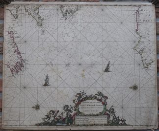
Antique map, titled: ‘Paskaerte van ‘t in comen Van ‘t Canaal, hoemen dat sal aen doen, als men iut de West comt.’ – (Sea Chart for entering the English Channel.) This antique sea chart shows the Atlantic Ocean with the coasts of northern Spain, western France, the tip of Cornwall and Wales, as well as the southern edge of Ireland. Depth soundings near The Channel. A decorative cartouche with mythological figures and putti. Two compass roses, rhumb lines and two ships depicted on the sea. From: ‘Atlas ofte Water-Weereld […]’ or the French ed. ‘L’Atlas de la Mer, ou Monde Aquaticque […]’, published by Pieter Goos in Amsterdam, 1667. Ref: Koeman Goos 2 or 2B.Artists and Engravers: Made by ‘Pieter Goos’ after an anonymous artist. Engraver and publisher: Pieter Goos (1616-1675) was a Dutch cartographer, engraver and publisher. He engraved for other publisher’s including Visscher and John Speed.He is well-known for his Atlas ofte Water-Weereld, a highly regarded maritime atlas. His father Abraham Goos worked with Henricus Hondius.
Condition: Fair, given age. Some staining. Paper edges irregular with some chipping and paper loss. Some paper loss ad lower cartouche, backed. Original middle fold as issued.. Some light paper spots, backed. Creasing in lower right corner. General age-related toning and/or occasional minor defects from handling. Please study scan carefully.
Keywords: ANTIQUE MAP-SEA CHART-ATLANTIC-THE CHANNEL-SPAIN-FRANCE-ENGLAND-GOOS
(PCO) GK-305


Reviews
There are no reviews yet.